
Showing posts with label AR Drone. Show all posts
Showing posts with label AR Drone. Show all posts
Tuesday, February 19, 2013
World's most popular consumer drone gains autonomous flight
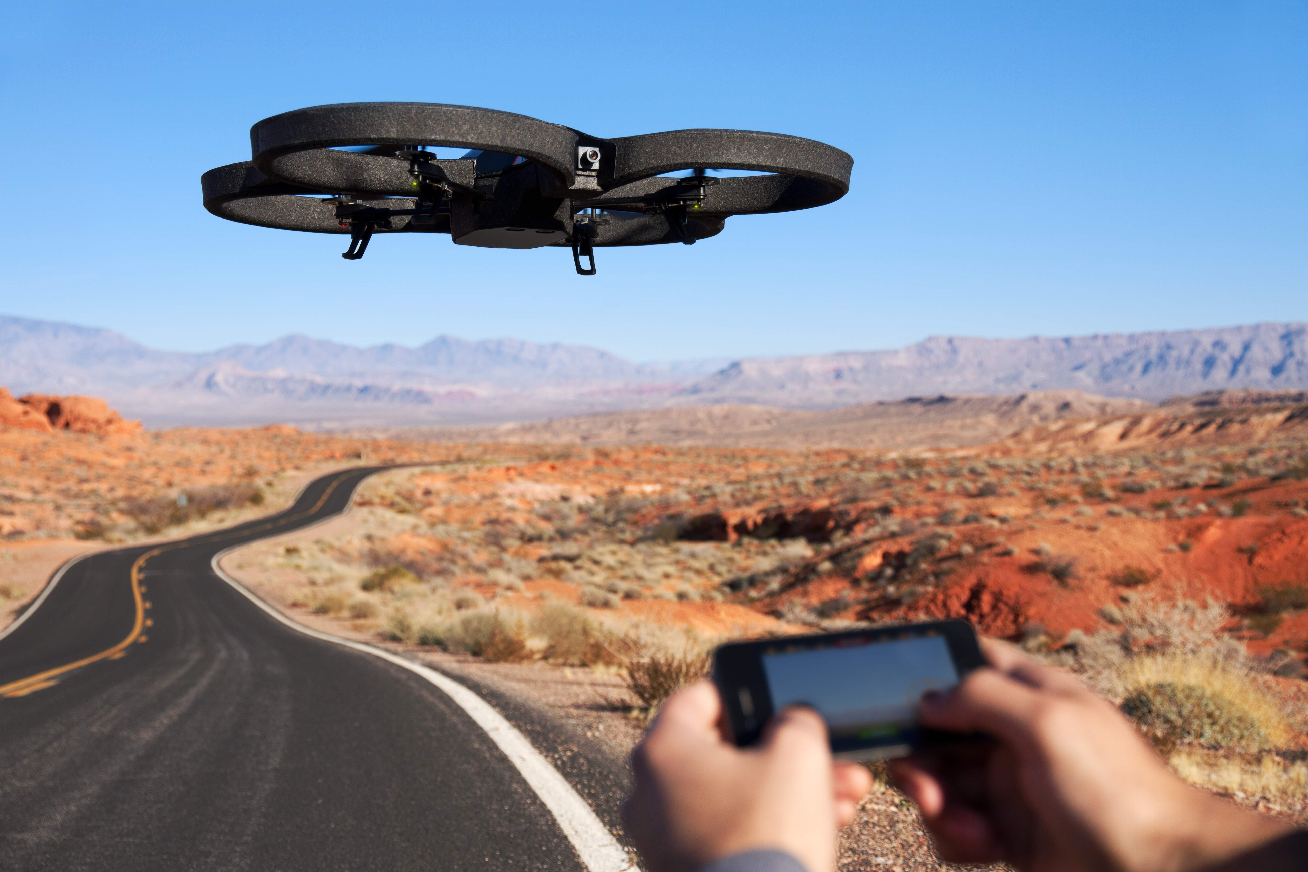
Since it was introduced in 2010, the AR.Drone has been a success among hobbyists, hackers, engineering students, drone journalists, activists, and aspiring UAS (Unmanned Aerial Systems) operators. Produced by the French wireless products manufacturer Parrot, this camera-enabled quadrotor can be controlled over WiFi via iOS or Android-enabled phones and tablets.
This has been the go-to item for many news organizations trying to understand the new world of UAS without a tremendous investment. The Sydney Herald recently used one to help bring context to their story about privacy concerns amidst the proliferation of "drones."
A news crew in Florida also tried using an AR.Drone to get a better view of a live event, but they were chased out of the sky by angry bees.
Since launch, it has sold over 300,000 units. That's ten times the number of UAS that the FAA anticipated would by flying in American airspace... by 2020.
A selling point of the RC aircraft from the beginning has been augmented reality dogfights with other AR.Drones, facilitated by on-board image recognition. Parrot recently unveiled another addition to the drone's list of AR abilities -- a GPS receiver.
Friday, July 27, 2012
Maker of the AR Drone invests in GIS. Is cheap, commerical drone mapping on the way?
Many people's first introduction to commercial drones may have been the AR Drone by Parrot. Originally marketed as a futuristic RC toy you control via WiFi with an augmented reality iPhone AP, the AR Drone is a consumer-grade, $300 quadrotor with an HD Camera, the first of its kind that has been mass produced.
Parrot, the company that develops and manufactures the drone, have sold 300,000 ARs since 2010 (to put the number in perspective, the FAA estimates 1/10 that number of commercial drones will by flying in the national airspace alongside manned aircraft by 2020). It's also developed a user base that is constantly tweaking the drone and figuring out new uses.
Videographers have rigged the AR Drone with higher-end cameras and found ways to extend its range. Occupy activists have tried to hack them to broadcast live video of protests. They've also been tested as potential platforms to conduct drone journalism at The University of Nebraska's Drone Journalism Lab.
Yesterday, Pix4D, a company that specializes in making software that converts aerial shots from drones into 3D photomaps, announced that it would be receiving a $2.4 million investment from Parrot.
"With the fast technological advances in miniaturized autopilots and digital cameras, lightweight autonomous flying platforms are increasingly used to generate up-to-date and detailed environmental maps and geographical information data," Pix4D said in a press release. "Furthermore, recent changes to the regulatory framework for civilian drones will drive UAV adoption and help address the soaring demand for GIS data."
Christoph Strecha, CEO of Pix4D appeared in a recent video along with Jean-Christophe Zufferey, CEO of senseFly, who also received funding from Parrot. SenseFly produces the "Swinglet Cam," a micro drone system designed for photomapping missions.
In the video, Strecha said it would be "interesting" for his company to step into "To produce games, to produce augmented reality that can be done with quadrotors for the consumer market."
The investment from Parrot, who made quadrotors accessible to average consumer, begs the question as to whether the consumer electronics manufacturer will attempt to do with GIS photomapping what it did to commercial drones. Could a $300 drone mapping system be far off? Would journalists adopt such a device for their reporting? How about city planners, environmental researchers, and construction companies -- would they adopt it as well?
Pix4D hasn't responded yet to questions, but I will update if they do.
Joint video announcement by Pix4D and senseFly

A drone-generated photomap of Port Au Prince, Haiti, generated by Pix4D software.
Wednesday, December 14, 2011
Founding a Professional Society of Drone Journalists

It’s been quite a month for drones. After Iranian armed forces captured one of the coveted American RQ170 stealth drones, the very same stealth drone that pierced Pakistani airspace to spy on Osama bin Laden, Wired’s Spencer Ackerman released previously unpublished photos of the carnage that U.S. military drones unleashed in Waziristan.
Later, the Los Angeles Times wrote about how the U.S. Customs and Boarder Protection lent a Predator B drone to North Dakota law enforcement. Sheriffs in Nelson County, N.D., fearing a search for missing cattle would end with deadly firefight with a “sovereign citizen” group, spied on the group and arrested members after the drone revealed they were unarmed. The report went on to reveal that local law enforcement had used Predators stationed at the Grand Forks Air Base for at least two dozen surveillance flights since June, and the FBI and DEA have used Predators in their own investigations.
Salon’s Glen Greenwald warned of the expansion of domestic drones, and the sizable lobbying power of drone contractors in Congress, writing “the escalating addition of drones — weaponized or even just surveillance — to the vast arsenal of domestic weapons that already exist is a serious, consequential development. The fact that it has happened with almost no debate and no real legal authorization is itself highly significant.”
Meanwhile, the Washington Post dedicated its December 4 front page to the Israeli military’s use of drones in Gaza. But one Post reporter asked the question that journalists like me have been wondering for some time: What’s the potential use for drones in journalism?
Melissa Bell’s piece, “Drone journalism? The idea could fly in the U.S.” mentions my writing on a drone journalism Google group, where I mention that drone technology could help journalists “to take water or air samples or to scan for topographical data to make assessments about industrial impact on the environment.”
Bell mentioned Matt Waite, a journalism professor at the University of Nebraska – Lincoln and developer of Pulitzer Prize-winning Politifact, who just began the world’s first drone journalism lab. Waite unveiled his plan for a drone journalism lab at a News Foo conference, where the immediate reaction was skepticism.
“News Foo had a number of tech people very interested in and sensitive to privacy issues and they were quite wary,” Waite told data journalist Ben Welsh. “They immediately went to TMZ+Lindsay Lohan as an example of how drones could be misused.
“So when I started thinking about this idea, I immediately thought that people would rightfully be wary of this and that the sooner we started talking about ethics and laws, the sooner we could have answers for criticisms and guidelines to balance the public’s right to know and people’s expectations of privacy.”
I was unaware of Waite’s announcement, or his drone journalism lab, until the WaPo story. But given the most spectacular breach of journalism ethics in recent history (the News of the World/NewsCorp phone hacking scandal), it was not lost on me how important it would be to establish a code of ethics for drone journalists. The code of ethics would be deliberated and drawn up by experts in the field, similar to the way the Society of Professional Journalists developed and supported its code of ethics.
To that end, I purchased Dronejournalism.org as the future home of the Professional Society of Drone Journalists (PSDJ). At the time of this post, the website is dominated by a placard that displays the mission statement of the PSDJ: “Dedicated to developing the ethical, educational and technological framework for the emerging field of drone journalism.”
I also called Waite to bounce ideas about the first professional organization for drone journalists. One of his ideas was that the organization pursues a code of ethics via Wiki-style collaboration, but that the collaboration should only involve experts and practitioners of drone journalism. He, too, realized the need for an organization to help pull down a concrete ethical framework for journalists.
“This is really cool on one side, really creepy on the other,” Waite said in the conversation. “I think you are being dishonest if you are on the cool side, not thinking there’s something creepy about [drone journalism]. There’s a significant opportunity for mayhem and privacy violations.”
On the other hand, he said, “I think you are missing the point if you don’t see the amazing things you can do with the technology.”
For an example, Waite pointed out that Russian citizen journalists had employed an SLR-equipped drone to obtain aerial shots of a recent protest. The Daily Beast, one of the first news organizations to use a drone, surveyed tornado damage in Joplin, Missouri, and flood damage in Natchez, Mississippi and Minot, North Dakota.
Video from a citizen journalist capturing footage during Poland protests.
But there’s two other components to the PSDJ besides ethics: education and technology. We need to teach journalists how to use the equipment safely and effectively, and we need to keep journalists at the forefront of civil drone technology.
Waite used a $1,000 grant from the company he founded to purchase an off-the-shelf drone, the AR Drone quadcopter by Parrot, to be equipped later with a GoPro HD video recorder. Out of the box, the AR Drone provides a relatively stable platform for shooting video, and is controllable by iPhone or Android smartphone. Steve Doig, a Pulitzer Prize-winning data journalist who teaches at ASU, also is experimenting with the AR Drone platform.
"You can get it at Brookstone in the mall," Waite said. "It's got an API and you can hack it. It's made of stock parts. You can controll it from your smartphone. And it's cheap."
 |
| A Parrot AR Drone in flight. |
The next step for me will likely be purchasing the same drone and outfitting it in the same fashion. Not too much later, I hope to be able to develop some Arduino-based, fixed-wing aircraft to shoot photos along a predetermined path, and stitch those photos together later. But Waite and I know this is just a starting point; an inexpensive, yet effective demonstration of the concept. From there, it’s experimentation and learning.
“What I would love to do, once we have these platforms, is let’s cover some news,” Waite said. “A house fire in your city. Spring floods. There will be tornadoes, it’s as predictable as the sun coming up. Let’s cover them and write about our experiences and through those.”
Subscribe to:
Posts
(
Atom
)