Above is an aerial mosaic -- a series of 11 photos taken from a small unmanned aerial vehicle (colloquially known as a drone) that have been stitched together in a mosaiking program.
That program, Microsoft Image Composite Editor, is normally used to stitch together a series of sweeping photos taken from the ground to make a single panoramic image. However, the algorithm used to find and match the edges of a series of sweeping photos of, say, the Grand Canyon, is the same algorithm needed to fit photos together to make a map or similar map-esque image from aerial photos.
So, what kind of drone journalism could you do with this kind of image? Aerial photographers have been able to capture a breathtaking, panoramic view of Moscow protests from drones. These drones offer a perspective that is especially helpful at documenting the scope or extent of protests, political rallies, construction projects, landmarks, geographic features, and natural and man-made disasters.
But what kind of data journalism can you do with these drones? That's to say, what kind of hard data can you obtain from these images to launch investigations? How about proving the existence of or extent of something, such as oil spills, wild fires, droughts, or lax construction codes following a disaster, with actual metrics?
Despite JournoDrone 2 still being in the shop after its maiden flight, drone development is continuing onward and upward. Above is an aerial photo taken from my latest drone project, which has caused that previous drone to collect dust in the basement.
However, this new drone is superior in at least a couple of ways. One, it's much more stable in flight, thanks to its 68.5" wingspan. Its size also means it can loft a larger payload. The photo above was taken using an 11Mpx GoPro Hero 2, which is small, but has a not insignifcant weight penalty.
JournoDrone 2 was a plastic shell that I wrapped in carbon-fiber and epoxy, which could take a crash on the nose without much harm. This newest drone is made of balsa wood, but it's such a docile aircraft that the need for crash resistance is minimal. All that balsa, some 5 or so pounds of it, is also pretty good at flexing and absorbing a hard landing.
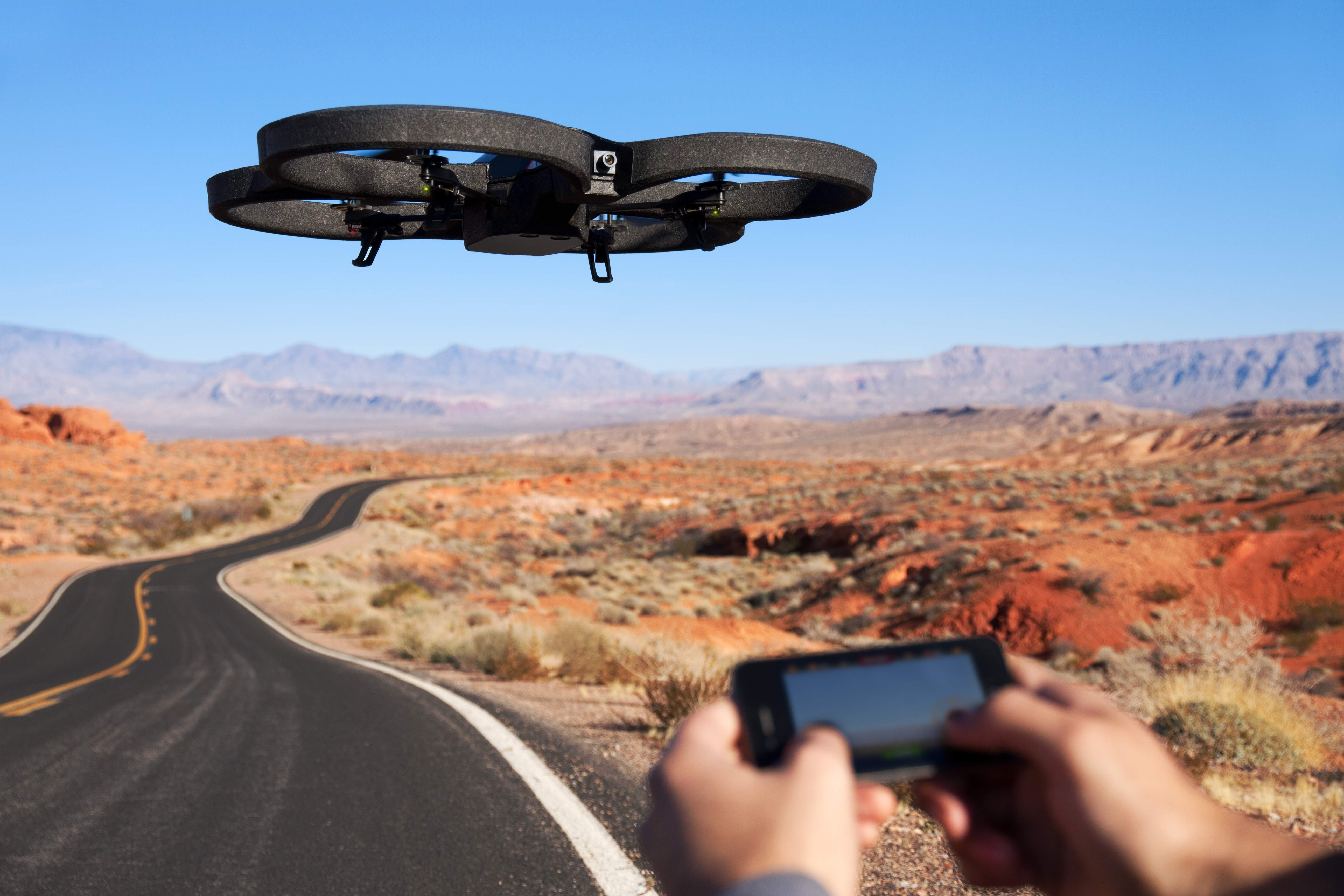
Many people's first introduction to commercial drones may have been the AR Drone by Parrot. Originally marketed as a futuristic RC toy you control via WiFi with an augmented reality iPhone AP, the AR Drone is a consumer-grade, $300 quadrotor with an HD Camera, the first of its kind that has been mass produced.
Parrot, the company that develops and manufactures the drone, have sold 300,000 ARs since 2010 (to put the number in perspective, the FAA estimates 1/10 that number of commercial drones will by flying in the national airspace alongside manned aircraft by 2020). It's also developed a user base that is constantly tweaking the drone and figuring out new uses.
Yesterday, Pix4D, a company that specializes in making software that converts aerial shots from drones into 3D photomaps, announced that it would be receiving a $2.4 million investment from Parrot.
"With the fast technological advances in miniaturized autopilots and
digital cameras, lightweight autonomous flying platforms are
increasingly used to generate up-to-date and detailed environmental maps
and geographical information data," Pix4D said in a press release. "Furthermore, recent changes to the
regulatory framework for civilian drones will drive UAV adoption and
help address the soaring demand for GIS data."
Christoph Strecha, CEO of Pix4D appeared in a recent video along with Jean-Christophe Zufferey, CEO of senseFly, who also received funding from Parrot. SenseFly produces the "Swinglet Cam," a micro drone system designed for photomapping missions.
In the video, Strecha said it would be "interesting" for his company to step into "To produce games, to produce augmented reality that can be done with quadrotors for the consumer market."
The investment from Parrot, who made quadrotors accessible to average consumer, begs the question as to whether the consumer electronics manufacturer will attempt to do with GIS photomapping what it did to commercial drones. Could a $300 drone mapping system be far off? Would journalists adopt such a device for their reporting? How about city planners, environmental researchers, and construction companies -- would they adopt it as well?
Pix4D hasn't responded yet to questions, but I will update if they do.
Joint video announcement by Pix4D and senseFly
A drone-generated photomap of Port Au Prince, Haiti, generated by Pix4D software.
We almost had it. After months of research, development and heartache, DroneJournalism.org was about to have its very first aerial photographs. And while it wasn't going to be from a drone, these photos would be gathered easily and available instantly.
The balloon went up, the line went out, but something didn't seem right. And then... well, in short, on Wednesday, May 2, at approximately 4:00 p.m., we almost had it. What was it, exactly?
When JournoDrone One met its end last month, taking one final dive into the grass and shattering into foamy bits, it dashed the hopes of DroneJournalism.org developers of an easy solution to drone journalism. However, we were well aware that this enterprise had a learning curve. And we did have some measure of success, and learned some valuable lessons that will help us and other drone journalists in the future.
We can say for certain that the drone flew. It didn’t fly very high – 12 feet or so – or for very long – perhaps 5 seconds at most. But it did fly.
Above is the only on-board footage of the first and only flight of JournoDrone One. For most of the video, the shadow of the drone’s nose is visible in the bottom of the image, except for the last few seconds when the drone lifts off. That’s when the image starts to bob and weave, because there’s no longer wheels and landing gear keeping the craft stable.
Only one minute and eight seconds could be recovered from the GoPro HD camera mounted to the bottom of the craft. That’s because I maneuvered the aircraft with very little altitude, and inadvertently sent it in a downward trajectory. Upon impact, the GoPro separated from its mounting case and ejected its SD card before it had a chance to write the remainder of the flight to the card. This also corrupted the file, and so a freeware program was used to recover what little footage the GoPro managed to record.
What went into the drone, and what did I get out of it? Here’s the details.
JournoDrone One outfitted with a small HD camera for aerial videography. The potential for these devices to capture live video from the sky, on the cheap, has generated interest from the television news industry.
Although we’re several years away in terms of regulation and technology for making drones a feasible, low-cost platform for television news, the television news industry has started to talk about using drones to enhance coverage.
Myself, along with Matt Waite of Nebraska’s Drone Journalism lab, were recently interviewed by the television news trade journal TV Technology. It briefly mentions DroneJournalism.org and our (unfortunately now departed) JournoDrone One (pictured above).
Tom Butts, the writer of the piece and the editor in chief of the TV Technology magazine, focuses mainly on drones as a cheap alternative to manned helicopters for live news events. He also draws attention to how ethical or technical mishaps with drone technology could slow or prevent the adoption of drone technology in the TV broadcasting industry.
Here’s some excerpts below:
Drone Journalism: The News Choppers of Tomorrow By Tom Butts
For TV news crews, operating an “eye in the sky” means hundreds of thousands of dollars per year in aircraft maintenance and fuel costs. Using choppers also comes with inherent risks that have resulted in numerous accidents over the years.
As stations look to save money while reducing safety concerns, some in the news business are beginning to examine the use of unmanned aerial vehicles to obtain highly valuable news coverage from above. While it’s a relatively new concept for journalists, the technology of “drone journalism” is familiar and extremely cost-effective when compared to traditional aircraft.
In essence, drone journalism involves the use of remote-controlled small aircraft outfitted with cameras to acquire footage from the air. What defines “aircraft” could be anything from a toy helicopter purchased at the local mall to more sophisticated devices, and the camera could be a typical point-and-shoot to a more expensive DSLR with video capabilities.
There’s just one problem. The use of such devices is illegal in the United States – for now, at least. Last month, as part of its latest budget, Congress gave the Federal Aviation Administration until 2015 to develop a set of rules and guidelines authorizing the commercial use of such remote-controlled unmanned aerial devices. And several researchers and entrepreneurs are exploring the technical – and perhaps even more important – ethical uses of these drones.
…
JOURNODRONE
Matthew Schroyer, a drone and data journalist at the University of Illinois-Champagne [sic] created dronejournalism.org as a forum to discuss and share ideas about the subject and is developing a UAV dubbed the “JournoDrone,” based on designs from diydrones.com. Schroyer is approaching the subject matter more from a data-gathering standpoint, using still photographs to stitch together maps from aerial surveying.
“We are getting to the point where a journalist can build a drone for himself and fly it and use it to collect all sorts of interesting data and information that you couldn’t get before without this perspective,” Schroyer said. “These platforms are so versatile… I could really see this technology taking off and being adopted in a lot of newsrooms.”
Up until now, must of the public has become aware of drones through news reports about their use in military operations – and then only when something goes wrong. This has created a public relations problem that both [Matt] Waite [a professor of journalism at the University of Nebraska-Lincoln] and Schroyer believe could be compounded if the commercial use of drones is abused, specifically to violate people’s privacy.
“We don’t send photographers to people’s houses with long telephoto lenses and we don’t trespass on someone’s private property to use those lenses to take pictures through people’s windows,” Waite said. “Why would using a drone make that any more OK? It wouldn’t. There are significant questions of people’s rights, the right to assembly and the government’s powers to monitor people that come with this technology.”
…
What happens if the paparazzi start using drone cameras to spy on celebrities? How far would they go? This is one of Schroyer’s main concerns. “The entire field of dorne journalism could be stifled by one incident and then we could lose all this reporting ability,” he said. “We don’t want that to happen.”
Meantime, I'll be delivering news on the status of JournoDrone One here and on DroneJournalism.org in the near future. That update will have information on our progress, where we're headed in the near future, as well as advice for drone journalists who are trying to develop their own drones.
Aerial photograph of Harrisburg, IL. Not taken by JournoDrone One.
Today, the southern Illinois town of Harrisburg is morning six of its own who were killed by a 170 mile per hour, 200 yard tornado. It was one of the 16 tornadoes that ripped through Nebraska, Kansas, Missouri, Illinois and Kentucky, claiming 13 lives.
Tuesday night, while news networks came from far and wide to cover the devastation on the ground, I worked to prepare JournoDrone One to film the disaster from the sky. For better or worse, the drone never made it to Harrisburg.
JournoDone One is a test mule for DroneJournalism.org, which myself and fellow drone journalism developer Acton Gorton hope will pave the way for a low-cost, highly durable and transportable small Unmanned Aerial System (sUAS) for journalists.
JD-01 had never flown a mission before, let alone been tested. So the idea of rushing to Harrisburg and filming anything was a long shot, but something I felt I needed to try. This was a disaster just three and a half hours’ drive from home base, and if I had anything to say about it, I would be putting my equipment to good use. And I do venture to natural disasters on a whim.
Of course, it wouldn’t do any good to drive to the storm-ravaged town of Harrisburg just to nose-dive a drone into the rubble after takeoff. The town had enough grief and did not need some clumsy pilot crashing drones into things and making things worse. So instead, I had a test flight in Champaign, where I dove the drone into a freezing field. Here’s what happened.